Log in
All resources
Create a design
4,035 Free Images of World Map
beschreibung und contrafactur der vornembster stät der welt, liber primus civitates orbis terrarum
bibliothèque nationale de france
maps
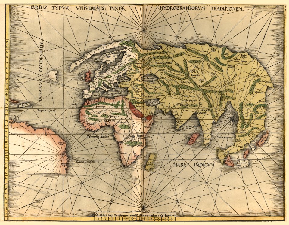
atlas sive cosmographicae (gerardus mercator, 1607)
globe
continent
earth
world globe
cartography
geography
atlas sive cosmographicae (gerardus mercator, 1607)
maps of mexico by mercator-hondius
atlas sive cosmographicae (gerardus mercator, 1607)
maps of asia minor by mercator-hondius
atlas sive cosmographicae (gerardus mercator, 1607)
maps of rügen by eilhard lubinus
atlas sive cosmographicae (gerardus mercator, 1607)
maps of castile by mercator-hondius
atlas sive cosmographicae (gerardus mercator, 1607)
maps of lake geneva by jacques goulart
atlas sive cosmographicae (gerardus mercator, 1607)
maps of south asia by mercator-hondius
atlas sive cosmographicae (gerardus mercator, 1607)
maps of asia by mercator-hondius
lawrence h. slaughter collection of english maps, charts, globes, books and atlases
nypl lionel pincus and princess firyal map division
1949 stamps of the german bizone
males on stamps
map of the upper rhenian circle by sanson
maps by nicolas sanson
maps of america by guillaume delisle (18th century)
1760s maps of the americas
corona and coronet (1898)
1898 maps of the world
maps by willem and johannes blaeu
1630s maps of the world
continent
maps
mappe-monde geo-hydrographique (sanson and jaillot, 1674)
bibliothèque nationale de france
bibliothèque nationale de france
guillaume sanson
details of old maps
michael burghers
eran laor cartographic collection
jan goeree
engravings by romeyn de hooghe
engravings by jan luyken
planet
maps
beschreibung und contrafactur der vornembster stät der welt, liber primus civitates orbis terrarum
maps of rhodes by braun & hogenberg
bibliothèque nationale de france
sanson map of lorraine
beschreibung und contrafactur der vornembster stät der welt, liber primus civitates orbis terrarum
maps of vienna by braun & hogenberg
beschreibung und contrafactur der vornembster stät der welt, liber primus civitates orbis terrarum
maps of würzburg by braun & hogenberg
beschreibung und contrafactur der vornembster stät der welt, liber primus civitates orbis terrarum
maps of toledo by braun & hogenberg
beschreibung und contrafactur der vornembster stät der welt, liber primus civitates orbis terrarum
maps of dresden by braun & hogenberg
beschreibung und contrafactur der vornembster stät der welt, liber primus civitates orbis terrarum
maps of nîmes by braun & hogenberg
beschreibung und contrafactur der vornembster stät der welt, liber primus civitates orbis terrarum
maps of lübeck by braun & hogenberg
beschreibung und contrafactur der vornembster stät der welt, liber primus civitates orbis terrarum
maps of montpellier by braun & hogenberg
beschreibung und contrafactur der vornembster stät der welt, liber primus civitates orbis terrarum
maps of genoa by braun & hogenberg
bibliothèque nationale de france
sanson map of lorraine
beschreibung und contrafactur der vornembster stät der welt, liber primus civitates orbis terrarum
maps of écija by braun & hogenberg
beschreibung und contrafactur der vornembster stät der welt, liber primus civitates orbis terrarum
maps of wittenberg by braun & hogenberg
beschreibung und contrafactur der vornembster stät der welt, liber primus civitates orbis terrarum
maps of brouwershaven by braun & hogenberg
maps by willem and johannes blaeu
1640s maps
beschreibung und contrafactur der vornembster stät der welt, liber primus civitates orbis terrarum
maps of kassel by braun & hogenberg
17th-century maps of the indian ocean
maps by willem and johannes blaeu
16th-century maps of hispaniola
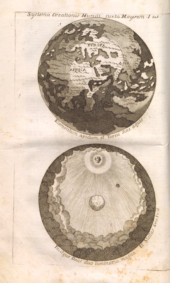
cornelius aurelius world map
old maps of veliky novgorod
maps of velikiy novgorod
1760s maps of the iberian peninsula
1762 maps of spain
1770s maps of alaska
robert de vaugondy
atlas sive cosmographicae (gerardus mercator, 1607)
maps of east flanders by pieter van der keere
earth
maps
potsdam conference on stamps
stamps of russia, 1995
17th-century paintings in the amsterdam museum
paintings by pieter isaacsz
astronomy
planet
continent
maps
old maps of westphalia
bindenschild
1560s maps of cyprus
giacomo franco
earth
maps
cartography
maps
german renaissance,northern renaissance
males on stamps
beschreibung und contrafactur der vornembster stät der welt, liber primus civitates orbis terrarum
maps of burgos by braun & hogenberg
nicolas desmarest
ambroise tardieu
pacific ocean in art
ships on maps
physical geography (1899) by davis
isotherm maps of the world
nicolas henri jeaurat de bertry
oil on canvas
old maps of the western hemisphere
jacob van meurs
beschreibung und contrafactur der vornembster stät der welt, liber primus civitates orbis terrarum
maps of toledo by braun & hogenberg
beschreibung und contrafactur der vornembster stät der welt, liber primus civitates orbis terrarum
maps of prague by braun & hogenberg
beschreibung und contrafactur der vornembster stät der welt, liber primus civitates orbis terrarum
maps of gorinchem by braun & hogenberg
beschreibung und contrafactur der vornembster stät der welt, liber primus civitates orbis terrarum
maps of mons (hainaut) by braun & hogenberg
beschreibung und contrafactur der vornembster stät der welt, liber primus civitates orbis terrarum
maps of lübeck by braun & hogenberg
beschreibung und contrafactur der vornembster stät der welt, liber primus civitates orbis terrarum
maps of marburg by braun & hogenberg
continent
maps
beschreibung und contrafactur der vornembster stät der welt, liber primus civitates orbis terrarum
maps of burgos by braun & hogenberg
beschreibung und contrafactur der vornembster stät der welt, liber primus civitates orbis terrarum
maps of dresden by braun & hogenberg
beschreibung und contrafactur der vornembster stät der welt, liber primus civitates orbis terrarum
maps of famagusta by braun & hogenberg
beschreibung und contrafactur der vornembster stät der welt, liber primus civitates orbis terrarum
maps of lisbon by braun & hogenberg (1572)
beschreibung und contrafactur der vornembster stät der welt, liber primus civitates orbis terrarum
maps of frankfurt (oder) by braun & hogenberg
beschreibung und contrafactur der vornembster stät der welt, liber primus civitates orbis terrarum
maps of genoa by braun & hogenberg
beschreibung und contrafactur der vornembster stät der welt, liber primus civitates orbis terrarum
maps of rouen by braun & hogenberg
beschreibung und contrafactur der vornembster stät der welt, liber primus civitates orbis terrarum
maps of arras by braun & hogenberg
penny arcade
world map
planet
earth
illustration
maps
beschreibung und contrafactur der vornembster stät der welt, liber primus civitates orbis terrarum
maps of sion by braun & hogenberg
beschreibung und contrafactur der vornembster stät der welt, liber primus civitates orbis terrarum
maps of tours by braun & hogenberg
beschreibung und contrafactur der vornembster stät der welt, liber primus civitates orbis terrarum
maps of vienna by braun & hogenberg
beschreibung und contrafactur der vornembster stät der welt, liber primus civitates orbis terrarum
maps of lisbon by braun & hogenberg (1572)
beschreibung und contrafactur der vornembster stät der welt, liber primus civitates orbis terrarum
maps of écija by braun & hogenberg
joseph stalin on stamps
stamps of russia, 1995
atlas, ou représentation du monde universel et des parties d'icelui, faicte en tables et descriptions très amples et exactes, divisé en deux tomes. édition nouvelle... - btv1b53103889w
maps facing west
atlas sive cosmographicae (gerardus mercator, 1607)
maps of île-de-france by françois de la guillotière
historical
history
maps by alexis-hubert jaillot
old maps of the tyrol
self-published work
pages with maps
atlas géographique des quatre parties du monde (delisle)
18th-century maps of the world
theatre geographique du royaume de france (1632)
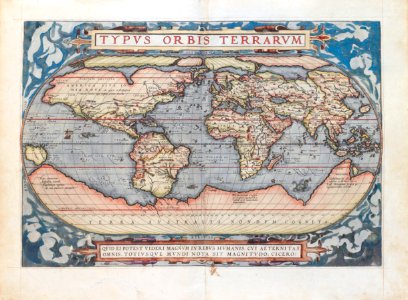
mercator 1587 world map
maps of alsace by guillaume sanson
1690s maps of baden-württemberg
political maps of the world
bombs in art
maps of alsace by guillaume sanson
1660s maps of baden-württemberg
maps of alsace by guillaume sanson
1690s maps of baden-württemberg
maps of alsace by guillaume sanson
1660s maps of alsace
map of ancient assyria by philippe de la rué
maps
1860s maps of china
1863 maps of asia
maps in the library of congress
propaganda map
australia
maps
astronomy
planet
maps by willem and johannes blaeu
1610s maps of the americas
2901 - 3000 of 4,035
Next page
/ 41


![Beschreibung und Contrafactur der Vornembster stät der Welt, liber primus [Civities of the World], 1574](https://cdn.creazilla.com/illustrations/10000199581/beschreibung-und-contrafactur-der-vornembster-stt-der-welt-liber-primus-civities-of-the-world-1574-sm.webp)

![Beschreibung und Contrafactur der Vornembster stät der Welt, liber primus [Civities of the World], 1574](https://cdn.creazilla.com/illustrations/10000603472/beschreibung-und-contrafactur-der-vornembster-stt-der-welt-liber-primus-civities-of-the-world-1574-sm.webp)
![Beschreibung und Contrafactur der Vornembster stät der Welt, liber primus [Civities of the World], 1574](https://cdn.creazilla.com/illustrations/10001109590/beschreibung-und-contrafactur-der-vornembster-st-t-der-welt-liber-primus-civities-of-the-world-1574-sm.jpg)
![Beschreibung und Contrafactur der Vornembster stät der Welt, liber primus [Civities of the World], 1574](https://cdn.creazilla.com/illustrations/10000869625/beschreibung-und-contrafactur-der-vornembster-stt-der-welt-liber-primus-civities-of-the-world-1574-sm.webp)
![Beschreibung und Contrafactur der Vornembster stät der Welt, liber primus [Civities of the World], 1574](https://cdn.creazilla.com/illustrations/10001235664/beschreibung-und-contrafactur-der-vornembster-stt-der-welt-liber-primus-civities-of-the-world-1574-sm.webp)
![Beschreibung und Contrafactur der Vornembster stät der Welt, liber primus [Civities of the World], 1574](https://cdn.creazilla.com/illustrations/10001559172/beschreibung-und-contrafactur-der-vornembster-stt-der-welt-liber-primus-civities-of-the-world-1574.jpg)
![Beschreibung und Contrafactur der Vornembster stät der Welt, liber primus [Civities of the World], 1574](https://cdn.creazilla.com/illustrations/10000396457/beschreibung-und-contrafactur-der-vornembster-stt-der-welt-liber-primus-civities-of-the-world-1574-sm.webp)
![Beschreibung und Contrafactur der Vornembster stät der Welt, liber primus [Civities of the World], 1574](https://cdn.creazilla.com/illustrations/10000465477/beschreibung-und-contrafactur-der-vornembster-stt-der-welt-liber-primus-civities-of-the-world-1574-sm.webp)
![Beschreibung und Contrafactur der Vornembster stät der Welt, liber primus [Civities of the World], 1574](https://cdn.creazilla.com/illustrations/10000676885/beschreibung-und-contrafactur-der-vornembster-stt-der-welt-liber-primus-civities-of-the-world-1574-sm.webp)

![Beschreibung und Contrafactur der Vornembster stät der Welt, liber primus [Civities of the World], 1574](https://cdn.creazilla.com/illustrations/10001057516/beschreibung-und-contrafactur-der-vornembster-stt-der-welt-liber-primus-civities-of-the-world-1574-sm.webp)
![Beschreibung und Contrafactur der Vornembster stät der Welt, liber primus [Civities of the World], 1574](https://cdn.creazilla.com/illustrations/10001167646/beschreibung-und-contrafactur-der-vornembster-stt-der-welt-liber-primus-civities-of-the-world-1574-sm.webp)
![Beschreibung und Contrafactur der Vornembster stät der Welt, liber primus [Civities of the World], 1574](https://cdn.creazilla.com/illustrations/10001294518/beschreibung-und-contrafactur-der-vornembster-stt-der-welt-liber-primus-civities-of-the-world-1574-sm.webp)

![Beschreibung und Contrafactur der Vornembster stät der Welt, liber primus [Civities of the World], 1574](https://cdn.creazilla.com/illustrations/10000927209/beschreibung-und-contrafactur-der-vornembster-stt-der-welt-liber-primus-civities-of-the-world-1574-sm.webp)


![[Isola di Cipro] / Jacomo Franco fecit, Giacomo Franco, 1569](https://cdn.creazilla.com/illustrations/10001061293/isola-di-cipro-jacomo-franco-fecit-giacomo-franco-1569-sm.webp)


![Beschreibung und Contrafactur der Vornembster stät der Welt, liber primus [Civities of the World], 1574](https://cdn.creazilla.com/illustrations/10001517687/beschreibung-und-contrafactur-der-vornembster-stt-der-welt-liber-primus-civities-of-the-world-1574-md.jpg)


![Beschreibung und Contrafactur der Vornembster stät der Welt, liber primus [Civities of the World], 1574](https://cdn.creazilla.com/illustrations/10000259768/beschreibung-und-contrafactur-der-vornembster-stt-der-welt-liber-primus-civities-of-the-world-1574-sm.webp)
![Beschreibung und Contrafactur der Vornembster stät der Welt, liber primus [Civities of the World], 1574](https://cdn.creazilla.com/illustrations/10000414570/beschreibung-und-contrafactur-der-vornembster-st-t-der-welt-liber-primus-civities-of-the-world-1574-sm.jpg)
![Beschreibung und Contrafactur der Vornembster stät der Welt, liber primus [Civities of the World], 1574](https://cdn.creazilla.com/illustrations/10000460304/beschreibung-und-contrafactur-der-vornembster-stt-der-welt-liber-primus-civities-of-the-world-1574-sm.webp)
![Beschreibung und Contrafactur der Vornembster stät der Welt, liber primus [Civities of the World], 1574](https://cdn.creazilla.com/illustrations/10001182290/beschreibung-und-contrafactur-der-vornembster-st-t-der-welt-liber-primus-civities-of-the-world-1574-sm.jpg)
![Beschreibung und Contrafactur der Vornembster stät der Welt, liber primus [Civities of the World], 1574](https://cdn.creazilla.com/illustrations/10000645695/beschreibung-und-contrafactur-der-vornembster-stt-der-welt-liber-primus-civities-of-the-world-1574-sm.webp)
![Beschreibung und Contrafactur der Vornembster stät der Welt, liber primus [Civities of the World], 1574](https://cdn.creazilla.com/illustrations/10001065727/beschreibung-und-contrafactur-der-vornembster-st-t-der-welt-liber-primus-civities-of-the-world-1574-md.jpg)
![Beschreibung und Contrafactur der Vornembster stät der Welt, liber primus [Civities of the World], 1574](https://cdn.creazilla.com/illustrations/10000427645/beschreibung-und-contrafactur-der-vornembster-stt-der-welt-liber-primus-civities-of-the-world-1574-sm.webp)
![Beschreibung und Contrafactur der Vornembster stät der Welt, liber primus [Civities of the World], 1574](https://cdn.creazilla.com/illustrations/10000623896/beschreibung-und-contrafactur-der-vornembster-st-t-der-welt-liber-primus-civities-of-the-world-1574-sm.jpg)
![Beschreibung und Contrafactur der Vornembster stät der Welt, liber primus [Civities of the World], 1574](https://cdn.creazilla.com/illustrations/10000713400/beschreibung-und-contrafactur-der-vornembster-st-t-der-welt-liber-primus-civities-of-the-world-1574-sm.jpg)
![Beschreibung und Contrafactur der Vornembster stät der Welt, liber primus [Civities of the World], 1574](https://cdn.creazilla.com/illustrations/10000732110/beschreibung-und-contrafactur-der-vornembster-stt-der-welt-liber-primus-civities-of-the-world-1574-sm.webp)
![Beschreibung und Contrafactur der Vornembster stät der Welt, liber primus [Civities of the World], 1574](https://cdn.creazilla.com/illustrations/10000573975/beschreibung-und-contrafactur-der-vornembster-st-t-der-welt-liber-primus-civities-of-the-world-1574-sm.jpg)
![Beschreibung und Contrafactur der Vornembster stät der Welt, liber primus [Civities of the World], 1574](https://cdn.creazilla.com/illustrations/10001069444/beschreibung-und-contrafactur-der-vornembster-st-t-der-welt-liber-primus-civities-of-the-world-1574-sm.jpg)
![Beschreibung und Contrafactur der Vornembster stät der Welt, liber primus [Civities of the World], 1574](https://cdn.creazilla.com/illustrations/10001343706/beschreibung-und-contrafactur-der-vornembster-stt-der-welt-liber-primus-civities-of-the-world-1574-sm.webp)
![Beschreibung und Contrafactur der Vornembster stät der Welt, liber primus [Civities of the World], 1574](https://cdn.creazilla.com/illustrations/10001574626/beschreibung-und-contrafactur-der-vornembster-stt-der-welt-liber-primus-civities-of-the-world-1574-sm.webp)

![Beschreibung und Contrafactur der Vornembster stät der Welt, liber primus [Civities of the World], 1574](https://cdn.creazilla.com/illustrations/10000920445/beschreibung-und-contrafactur-der-vornembster-stt-der-welt-liber-primus-civities-of-the-world-1574-sm.webp)
![Beschreibung und Contrafactur der Vornembster stät der Welt, liber primus [Civities of the World], 1574](https://cdn.creazilla.com/illustrations/10000639501/beschreibung-und-contrafactur-der-vornembster-st-t-der-welt-liber-primus-civities-of-the-world-1574-sm.jpg)
![Beschreibung und Contrafactur der Vornembster stät der Welt, liber primus [Civities of the World], 1574](https://cdn.creazilla.com/illustrations/10000691110/beschreibung-und-contrafactur-der-vornembster-st-t-der-welt-liber-primus-civities-of-the-world-1574-sm.jpg)
![Beschreibung und Contrafactur der Vornembster stät der Welt, liber primus [Civities of the World], 1574](https://cdn.creazilla.com/illustrations/10000735975/beschreibung-und-contrafactur-der-vornembster-st-t-der-welt-liber-primus-civities-of-the-world-1574-sm.jpg)
![Beschreibung und Contrafactur der Vornembster stät der Welt, liber primus [Civities of the World], 1574](https://cdn.creazilla.com/illustrations/10000353500/beschreibung-und-contrafactur-der-vornembster-stt-der-welt-liber-primus-civities-of-the-world-1574-sm.webp)